


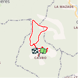
CAMBO - MONTAGNE DE LA FAGE - 7.6Km - 02h20 - Dénivelé 285 m

dansmabulle
User


2h29
Difficulty : Medium

FREE GPS app for hiking
 SityTrail
IGN / Geographical institutes
SityTrail Plus
The world is yours!
About
Trail Walking of 7.6 km to be discovered at Occitania, Gard, La Cadière-et-Cambo. This trail is proposed by dansmabulle.
Description
CAMBO - MONTAGNE DE LA FAGE
7.6Km - 02h20
Départ randonnée : Village de Cambo ( Gard 30) En partant de Cambo cette balade vous amènera sur les crêtes sud de la fage, vue magnifique sur la vallée de Cros au font , l'Aigoual le mont Lozère. Bonne randonnée
Positioning
Comments
Super balade !